

Blog
H2OVER® – going above and beyond


APEM’s digital aerial surveys are a quick and cost-effective way to identify and locate leaks, and map pipe routes for both clean water and wastewater networks.
This pioneering technique was developed by our remote sensing team in partnership with a major UK water company. The project’s success was recognised with a Water Industry Achievement Award for Innovation.
APEM have developed a unique approach using digital aerial surveys designed specifically for leakage mapping for the water industry.
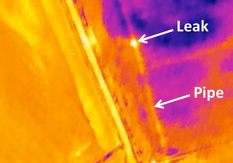
Our ‘leakage sensors’ can detect leaking pipes – above and below ground – quickly and over very large areas. Using aircraft mounted with state-of-the-art camera systems, the surveys collect both high resolution multi-spectral images and thermal data.
Specialist software is then used to spot the tell-tale signs of potential leaks using two specialist techniques. Water from leaking pipes can cause nearby vegetation to grow more vigorously and our specialist cameras are able to detect this. At the same time, we also gather thermal images that help to show the difference in temperature between wet ground and the surrounding land.

This innovative use of aerial surveys helps to locate pipe leaks efficiently over large areas. It also helps water companies to target the efforts of ground teams to where they are most needed, making it a time- and cost-effective solution.
Aerial surveys can cover large, remote or inaccessible areas with very little disturbance to people or wildlife, avoiding the need to secure permission from landowners to access their land. In addition, because aerial surveys cover large areas quickly, they can capitalise on optimum weather windows.
The maps we produce can be held in GIS and a series of surveys can show changes over time. The data generated by the surveys can then be used for other projects and for health and safety assessments on subsequent ground visits.
The team at APEM would be happy to answer any questions you have, please use the form below to get in touch.
Read one of APEM’s blogs, news articles or case studies to find out more.
APEM offers H2OVER®, a super-sized, high resolution survey that allows users to ‘virtually’ drive or fly through an area from their desktop
+ Read more

APEM continue to build on their relationship with United Utilities and are ready to help them map a series of buried assets … from the air!
+ Read more