

News
Ambiente joins APEM Group: strengthening environmental experti...

APEM’s Remote Sensing team have been using LiDAR as part of their technology arsenal since 2018.


We have recently invested in a further three sensors to better support the needs of clients across a variety of industries and throughout the world.
Simply put, a LiDAR (Light Detection And Ranging) scanner is a system for capturing highly accurate 3D data of the environment. A LiDAR sensor fires out a series of laser light pulses. Once the pulse hits an object and reflects back to the sensor, the difference in return timings allows an accurate 3D picture to be created.
LiDAR is therefore a highly accurate survey method that measures the heights of features such as the ground, trees and buildings.
By fitting a LiDAR system to an aircraft, it can scan the earth from side to side as it flies, allowing a large area to be covered quickly. Each point captured has an accurate X, Y, Z location tracked via GPS and as the scan takes place, data are digitally recorded which calculates the height of the surface that it meets.
Any turbulence or movement experienced during a scanning flight is accounted for via an IMU (Inertial Measurement Unit) and on the fly calculations are created and adjustments made. The data are then processed into a point cloud – a dataset of millions of individual points that map the environment, each with their own X, Y, Z coordinate attached.
Some of the key benefits for the use of LiDAR include:
Clients across many industries turn to APEM’s LiDAR services for projects such as topographic mapping, power line mapping, studies of woodland, archaeology, flood plain modelling, city planning, line of sight analysis and construction phase monitoring.
A key advantage of LiDAR is each pulse can yield multiple returns as it passes through vegetation. This allows for very detailed mapping of canopy structures making the data incredibly valuable for arboricultural surveys, forest inventorying and even carbon biomass calculations.
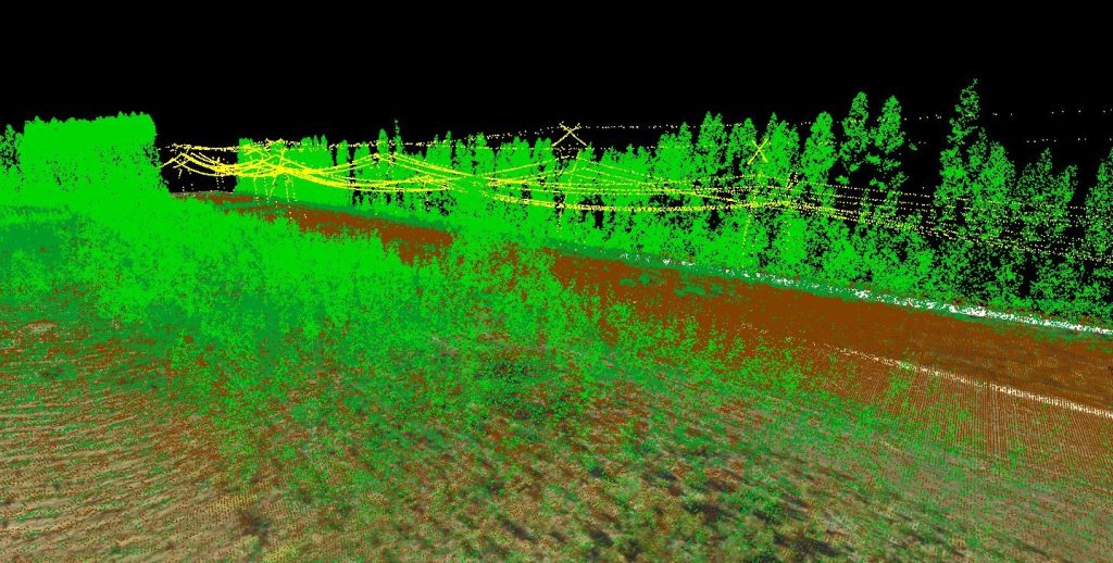
High-resolution imagery and point cloud data can be used to map and inspect above-ground features such as overhead power lines remotely and classified point clouds allow APEM to isolate features of interest.
In the image below you can see how ground points, overhead power line points and low and tall vegetation points can be visualised using LiDAR. Being able to select and interrogate different elements of an environment make point clouds a powerful tool for analysts.
Inaccessible locations are quick and cost-effective to fly and by utilising the different scanning types, APEM can identify features obscured by vegetation, without sending a person to site. Aerial surveying also removes site access issues and reduces health and safety risks on site.
LiDAR is just one of APEM’s remote sensing services, which also include:
As experts in remote sensing applications and outputs, our specialists provide recommendations for the most appropriate survey or combination of surveys to meet the needs of any project. We don’t advocate a ‘one size fits all’ approach, we treat every survey differently, following best practice survey design principles.
Our highly experienced team comprises of onboard aerial survey technicians, image analysts and remote sensing consultants, ensuring that at every step of the project from data operations, through to analysis and interpretation, modelling and recommendations, is managed seamlessly.
For further information regarding LiDAR or our wider remote sensing offering please contact Mark Wilkins, Principal Remote Sensing Scientist.
CSA Ocean Sciences is now part of APEM Group, bringing together complementary expertise to strengthen global marine and coastal environmental insight.
+ Read more

CSA Ocean Sciences is now part of APEM Group, bringing together complementary expertise to strengthen global marine and coastal environmental insight.
+ Read more

APEM Group today announced that Ambiente s.r.l., an Italian environmental engineering and consulting company providing technical and strategic advisory services
+ Read more
APEM Group today announced that CSA Ocean Sciences, a US based marine environmental consultancy supporting energy transition and coastal infrastructure projects
+ Read more